Using ATC routes in ForeFlight
While most agree that ForeFlight excels in the cockpit as an electronic chart viewer and navigator, there are also several planning features that are useful on the ground before flight. Making it easier to file a good flight plan is one of them.
For pilots flying IFR, it’s fairly common knowledge that ATC will typically not clear you for direct routing between airports if the flight spans a long distance, or if it passes through congested terminal airspace. The result is that many pilots spend a lot of time trying to guess a route ATC will like. Instead of always filing direct or guessing airways, let the “ATC Routes” tool in ForeFlight help you out.
Here’s how it works:
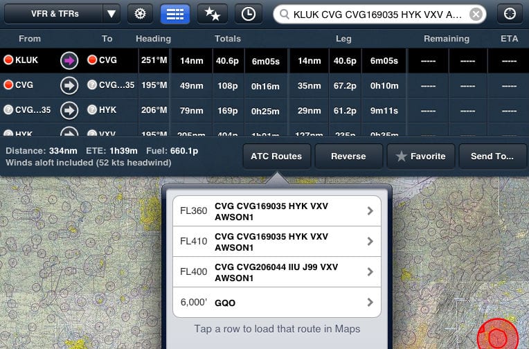
- In the Maps section of ForeFlight, enter your departure and destination airports; we’ll plan a flight from Cincinnati, OH (KLUK) to Atlanta, GA (KPDK) for this example.
- Bring up the Navigation Log by pressing its button in the toolbar
- At the bottom of the Log, you’ll see a button titled “ATC Routes”; pressing this will bring up a list of recently cleared ATC routes between the entered airports, including the altitude of the flight
- Tapping one of the routes will automatically load it into the Navigation log
This information can be helpful when filing IFR routing, and can help eliminate surprises when receiving your clearance in the airplane. Routes are typically only displayed between frequently travelled airports, so don’t expect to see ATC routes between rural county airports.
Also, use the altitude listed as a clue. ATC issues different routing for aircraft flying in the flight levels vs. those below 18,000 ft.
- Do I really need to use Airplane Mode on my iPad or iPhone Pilot? - December 31, 2025
- Flying with the Garmin D2 Mach 2 and D2 Air X15 - October 28, 2025
- Weather planning with Garmin Pilot: widgets and flight profile - October 22, 2025


I have noticed that the results shown here differ from those seen on fltplan.com. In some cases, I know for sure that there is a recent atc cleared route between two points because I received the earlier clearance. Fltplan.com shows those clearances but foreflight does not. Fltplan.com also shows nearby routing making planning considerably easier.