Pilot Report: New app measures visibility from your phone’s camera
|
Getting your Trinity Audio player ready...
|
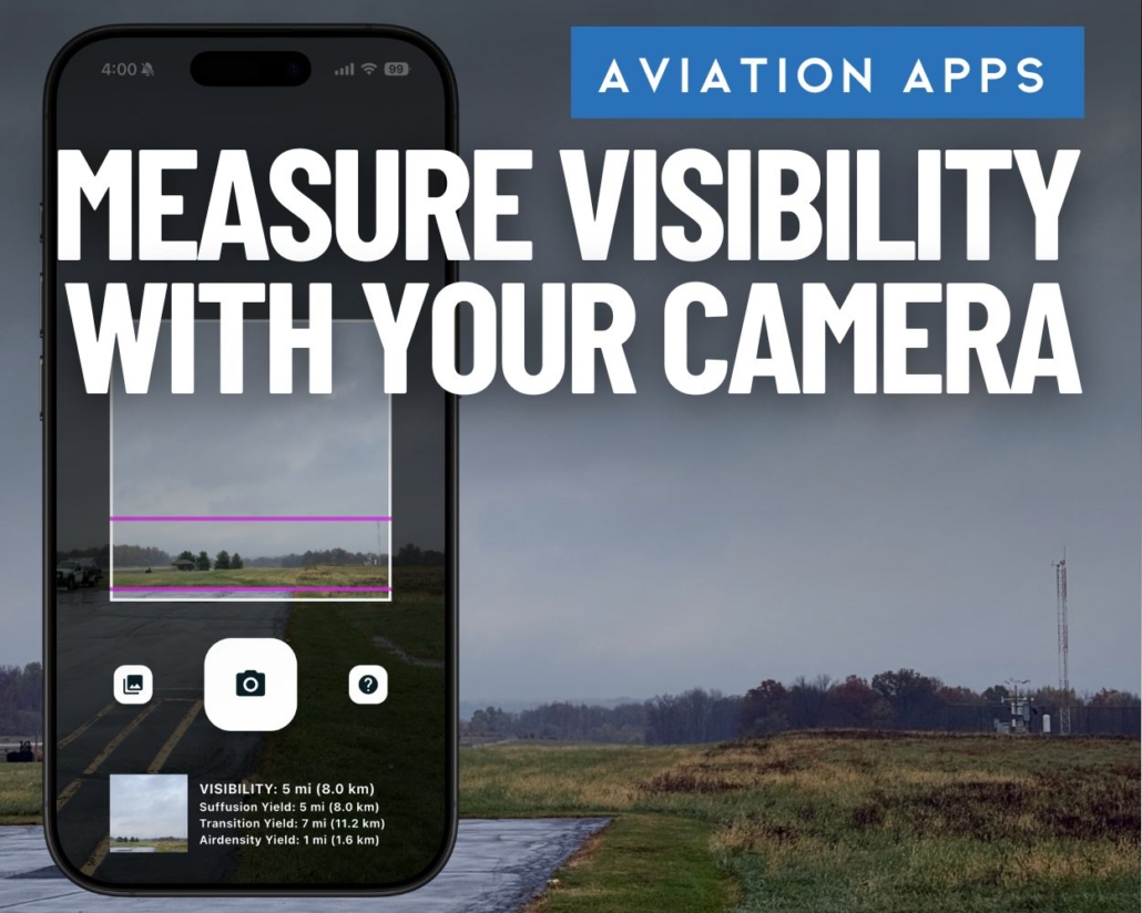
Turn your phone into a visibility sensor for safe and legal flights
Most pilots rely on METARs, ATIS, AWOS, and, of course, their own eyes when determining visibility. But what if your phone could give you an objective visibility reading anywhere, anytime? That’s the idea behind Visibility Tool, a new app developed by FlightProfiler, a veteran-owned company working with Ohio University and Ohio State University under a four-year research effort known as the Low Altitude Weather Network (LAWN).
Backed by funding from the Ohio Federal Research Network and the U.S. Air Force, with collaboration from NASA, the LAWN program’s goal is to build affordable, field-deployable weather tools for both manned and unmanned aviation. Visibility Tool is the first of several planned technologies—and it’s designed to work anywhere even without connectivity.
For pilots, the promise is a fast, accurate visibility estimate using nothing more than your phone’s camera. Simply point, click and get an accurate measure of visibility. That makes it useful for Part 107 operators, recreational drone flyers, and GA pilots—especially when verifying flight visibility for basic VFR weather minimums (91.155) compliance and overall safety in ensuring you’re meeting your own personal weather limitations. It won’t replace METARs or certified weather sensors, but it can add another layer of confidence to your go/no-go decision.
“I’m a VFR pilot without an instrument rating, and once or twice a year I’d find myself drifting toward inadvertent VFR into IMC. It’s scary—and I know it’s life-threatening. This tool combines my background in programming with a personal mission: reduce that inadvertent IMC risk for pilots like me.”—Ethan Krimins, President of FlightProfiler
It’s also worth noting that AWOS and ASOS visibility sensors measure only a tiny “micro” area—often just a few feet in front of the device. That makes the METAR visibility reading highly localized. The far end of the runway or the next valley over may be dramatically different. Visibility Tool aims to fill that gap by assessing visibility at a distance and breaking it down in one-mile increments, which can be more meaningful from a pilot’s perspective.
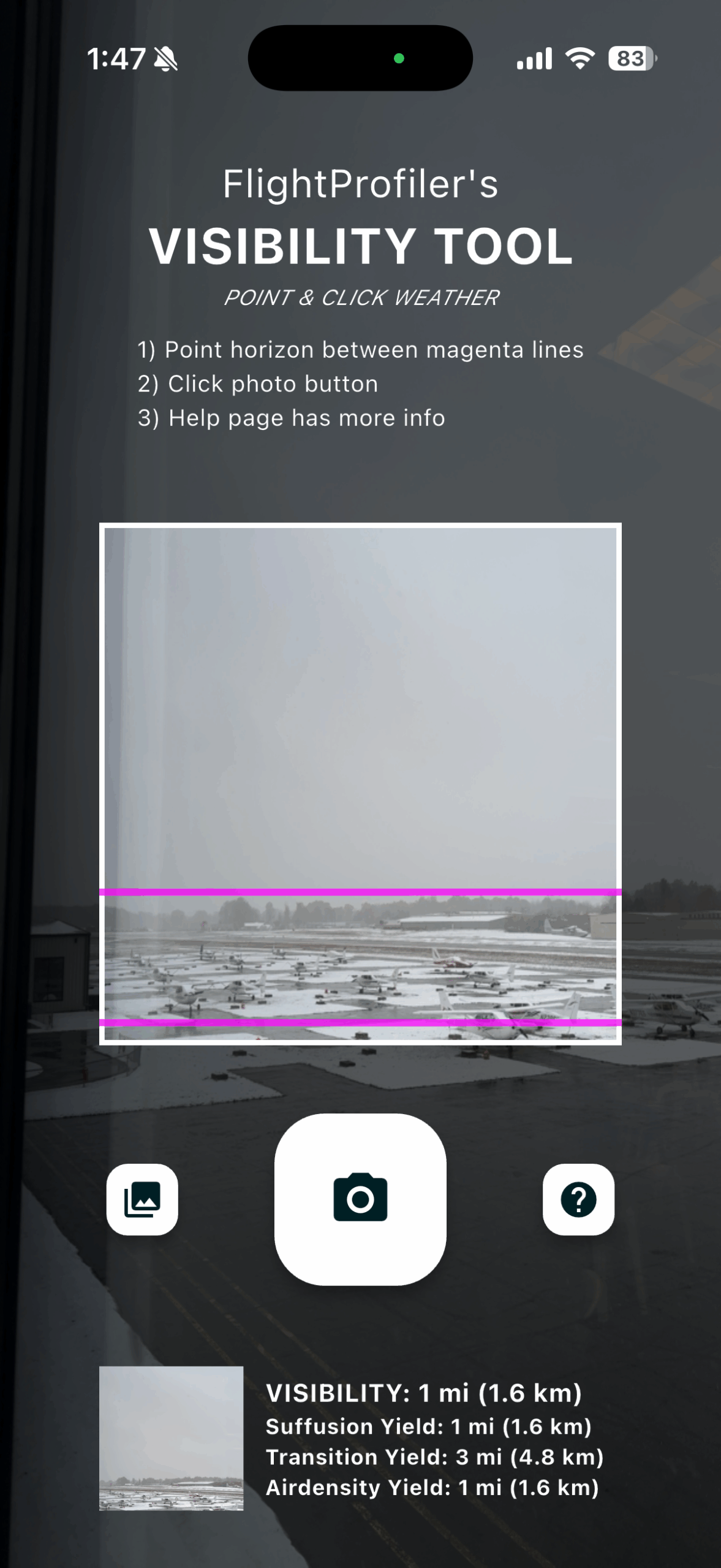
See the app in action
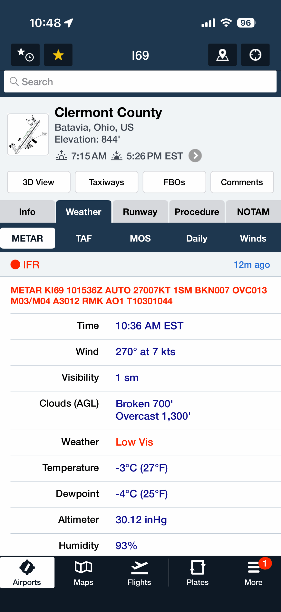
In this first example, the Visibility Tool image clearly shows limited forward contrast—objects fade quickly into haze, buildings lose definition, and terrain detail disappears within a mile. The app returns a reading of 1 mile, matching the AWOS report taken at the same time.
This scenario demonstrates the app’s usefulness in confirming marginal VFR conditions where the difference between just 1 and 2 miles can impact legality especially in Class G airspace.
Visibility = 1SM
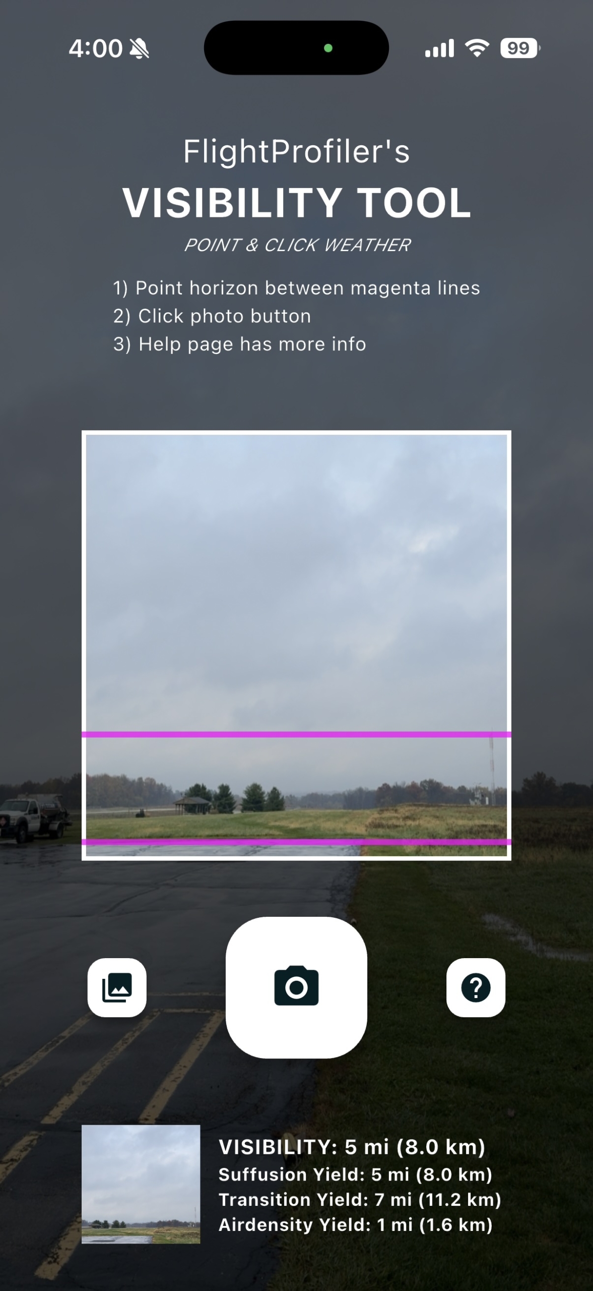
Next, the Visibility Tool captures a day with noticeably better definition. Treelines and hangar structures remain sharp, and the overall scene shows much deeper visual range. The app reports 5 miles, again aligning with the AWOS reading.
This comparison highlights the tool’s ability to scale with changing conditions and provide an objective check when conditions appear good but maybe not great. For drone pilots, this is a quick way to validate visibility for Part 107.51. For GA pilots, it’s a helpful cross-check or confirmation of VFR weather.
Visibility = 5SM
Visibility Tool isn’t meant to replace certified weather reporting, but as an additional data point—especially at non-reporting airports—it’s a surprisingly capable and affordable tool. The app works worldwide without connectivity, gives instant visibility estimates, and can help both drone operators and pilots double-check regulatory minimums before flying. Visibility Tool is available for iOS and Android for $9.99, and you can download it here:
Visibility Tool (Android version)

- Starlink Mini: Mounting Options Compared - March 6, 2026
- Backup Battery Roundup: How Much Power Do You Really Need? - February 27, 2026
- Product Report: Flight Gear Smart Suction Mount - February 13, 2026


The app sounded great. However, if one looks at the EULA, a few things stand out. First and foremost, the EULA says, “DO NOT USE THIS PRODUCT WHEN OPERATING A VEHICLE, INCLUDING BUT NOT LIMITED TO AIRCRAFT, AUTOMOBILES, BOATS, OR SELF-PROPELLED VEHICLES.” I.e., do not use it in the air. Then it says, “THIS PRODUCT IS FOR SCIENTIFIC RESEARCH PURPOSES ONLY. IT SHOULD NOT BE RELIED UPON TO DETERMINE ACCURATE VISIBILITY DATA. VISIBILITY DATA OBTAINED BY USING THIS PRODUCT INDIVIDUALLY, OR IN CONJUNCTION WITH OTHER SENSORS, TOOLS OR TECHNOLOGIES MUST NOT BE UTILIZED FOR DECISION MAKING. THIS PRODUCT SHOULD NOT BE UTILIZED FOR ANY DECISIONS INVOLVING GROUND OR AIR VEHICLES. THIS PRODUCT SHOULD NOT BE UTILIZED FOR FLIGHT SAFETY DECISIONS.”
In plain English: Do not use this application for the purposes we are advertising the application for.
Could it get worse? Sure: if you think you are buying an application, guess again: “This License confers no title or ownership in the Product and should not be construed as a sale of any rights in the Product” and “FLIGHTPROFILER grants You a non-exclusive, non-transferable, non-sublicensed, individual license to install and/or use the Product (in whole or in part) and any Product (the “License”), for such time until either You or FLIGHTPROFILER terminates this EULA.’
In plain English: You can pay us for the app, but if we feel like it, we can take it away at our whim.
That, plus (on Android at least) the developers say they are sending unspecified data to their servers in the clear, makes this a hard pass.
Hi Eric. Thanks for the comments. EULA language (especially in Europe) makes it difficult for us to deliver this technology, but not be held liable for users who may take risks with it, which could occur in a vehicle. As such, the specific language you have highlighted is put in place to protect the company. With respect to your second comment, this is taken directly from recommended Apple terms & conditions. If you are not comfortable with the language, we support your right not to use the Visibility Tool. However, if used properly, this technology will aid in reducing inadvertent VFR into IMC. Please consider using the technology and if you still feel its value is not appropriate given the above language, you can always obtain a refund via the Apple or Google Play stores where you purchased it. Thanks again and feel free to reach out to the FlightProfiler team directly – we would be happy to provide more background on the EULA language.
An impressive, pilot-focused innovation, the Visibility Tool delivers fast, intuitive, and genuinely helpful visibility data. This adds confidence to go/no-go decisions and complements status-quo METAR weather sources. There is an entire class of fixed-wing and rotor-wing aircraft pilots that would benefit from this additional data, especially given that their operations are not on traditional airfields. Congratulations to the team behind this tech and their focus on addressing one of VFR flying’s most persistent safety challenges.
As a recreational drone pilot and technology enthusiast, I’ve found this app super cool and helpful as an extra layer of confidence prior to taking off, especially when I plan to fly the drone more than a couple miles away. Very easy to use and intuitive. I am sure it can be helpful for other types of aircraft operators as well, it came in very handy for me throughout the fast-changing weather conditions we’ve had recently.