
How airline pilots are using crowd-sourced in-flight weather on their iPad
An interesting thing happened shortly after the iPad’s debut in 2010. As aviation EFB apps and portable ADS-B receives exploded in the GA market, the private pilot flying in a Bonanza or Cessna 182 gained a leg up on their pro pilot counterparts flying Boeing and Airbus airplanes.
While airline pilots were busy shuffling Jepp paper charts in leather binders, we were enjoying digital geo-referenced approach charts and airport diagrams, free datalink text and graphical weather and all the benefits that come with a paperless cockpit. Of course, it didn’t take long for the commercial industry to catch up and today just about all the major U.S. airlines depend on the iPad for digital chart and document management.
 Many airline pilots also now have access to datalink weather, but they’re not using ADS-B like we’re accustomed to. Instead they are using the WSI Pilotbrief app, which uses the airplane’s inflight internet connectivity as the data source (e.g. Gogo). This displays all the pertinent datalink weather products like radar imagery, METARs, TAFs, PIREPs, SIGMETs and more.
But there’s another component to this system that will make GA pilots envious – automated turbulence reporting. Developed by AeroTech Research, Inc. in partnership with WSI, The Turbulence Auto-PIREP System (TAPS) uses vertical accelerometers installed on certain Boeing and Airbus airplanes to continuously monitor in-flight g-loads. When turbulence is detected above a certain threshold, the data is sent back to WSI on the ground, processed, and then sent back to the WSI Pilotbrief app.
Turbulence “events” are depicted as a user-selectable overlay on the moving map in the WSI app, similar to how ForeFlight displays ADS-B PIREPs on the moving map. The reports also include other important weather data points captured by the airplane’s sensors, including altitude, winds aloft and temperature.
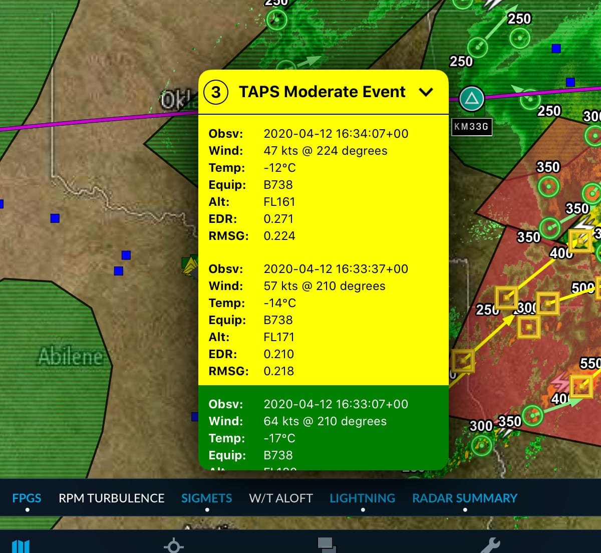
TAPS reporting has been installed on over 650 aircraft (B-737-800, B-757-200, B-767-300ER, B-767-400ER, A320 and A330) and has been well-received by airline pilots. In addition to helping pilots choose the best routes and altitudes for a smooth ride, the system also saves the airlines money by reducing unnecessary airframe inspections due to turbulence encounters.
It doesn’t take long to start dreaming up ways of how we could take advantage of crowd-sourced weather data like this in the GA world. Our number-one requested feature would be the ability to submit PIREPs in flight right from the aviation iPad apps (Stratus Insight offers this capability now). And it wouldn’t take long for Garmin, Appareo or uAvionix to develop affordable sensors to capture real-time turbulence metrics and other inflight data, which could then be shared with other pilots flying nearby.
The reality though is that none of this works until there is an affordable inflight internet solution for small airplanes. Until then, we’ll have to be content with the free one-way ADS-B weather data stream, and appreciate the technology the pilot at the front of your next airline flight is using to make sure the ride is as comfortable as possible.
- How to File an IFR Flight Plan in ForeFlight: A Comprehensive Guide - July 29, 2026
- iOS Update Green Light program: iOS and iPadOS 26.6 - July 27, 2026
- How to flight plan around thunderstorms using your iPad - July 15, 2026


I am curious why we need another sensor added to the aircraft when the iPad and iPhone already have accelerometers built-in that could be used to sense the level of turbulence. Foreflight/Wing-X/etc. could incorporate periodic sampling of the sensor as a new feature that could be transmitted automatically over a cellular data connection provided by an iPhone, cellular equipment iPad, or hotspot connected iPad. A little coordination with WxBrief-FSS could allow the current turbulence data to be sent as part of filing and closing a Flight Plan. Automatic cellular data transmission at the Flight Plan starting time and stopping at closing the flight plan. Foreflight also knows when you are flying, so speed could be another check before sending data. Time/position stamped recorded turbulence data could also be downloaded as part of closing a Flight Plan is it was not transmitted in flight. While not as precise or accurate as the airline setup, the increased low altitude coverage area would be greatly expanded.
As a major airline pilot and user of WSI,I have found that TAPS gives an overly optimistic impression of smooth air. Where a TAPS report indicates mostly smooth, there is rough air. Alternatively, WSI continues to improve, the color charts are especially good in contrast to the difficult to read Government sourced charts in Garmin Pilot. It would be a great improvement for GA to have access to the quality charts available in the WSI app.
Requirements for ADS-B downlink of PIREPs have been developed and are currently being reviewed by RTCA, EUROCAE, and ICAO, the standards bodies that set ADS-B standards. The requirements would allow EFB applications or avionics to transfer PIREP information confirmed by the pilot, including input from onboard sensors such as those built into the personal electronic devices on which EFB applications run, to ADS-B Out avionics for automatic transmission to the ADS-B Ground Receiver Network. Ground-based automation would encode a standard PIREP from received ADS-B messages for dissemination via existing networks to the NWS Aviation Weather Center, ATC, FSS, and via the internet. Dissemination of PIREPs to aircraft via FIS-B, which occurs today, would allow for PIREPs submitted via ADS-B to rapidly reach other aircraft in flight. The revised ADS-B standards (Version 3) are to be published later this year. The U.S. ADS-B mandate that took effect in January 2020 requires ADS-B Version 2 compliant avionics; there are no plans for regulators to require aircraft to equip with avionics meeting the Version 3 standards, however, manufacturers are planning to produce version 3 compliant ADS-B avionics once certification standards for them become available.