
Flying with the CloudTopper app
|
Getting your Trinity Audio player ready...
|
How many times have you been en route on a cross-country and wondered what the tops are on the cumulus clouds up ahead? Of course, deviating around them is an option for ensuring a smooth ride, but that also adds extra flight time. What if you could tell in advance whether or not your current altitude was high enough to clear the tops? That’s the purpose of one of our long-time favorite iPhone/iPad apps called Cloud Topper Pilot Sight Level. The app uses your iPhone or iPad’s internal camera, gyro, and accelerometers to help you hold the device level and display guides on the screen to gauge whether your current flight path will clear the tops.
We recently flew with the app on a cross-country trip from Ohio to Florida, where we expected the hot and moist summertime conditions would fire up some bumpy cumulus clouds along the way. After you open the app, hold it level so that the readout on the right shows as close as possible to 0.0° degrees. Clouds below the main reference line should stay under the current flight path, and clouds above the line are likely above it.
In this example, the app was held level as shown by the 0.0° pitch readout and allowed us to estimate that the top of the tallest buildup directly ahead is right at our current altitude. It continued to build as we got closer, requiring a minor deviation to avoid it:

The app worked great for keeping an eye on which clouds we would clear and which would require a heading change to steer clear and keep the coffee from spilling. While no thunderstorms were forecast along our route, the clouds eventually grew above our maximum altitude for the day. It was then time to go back to basics and ask ATC for deviations around the buildups to maintain a smooth ride:
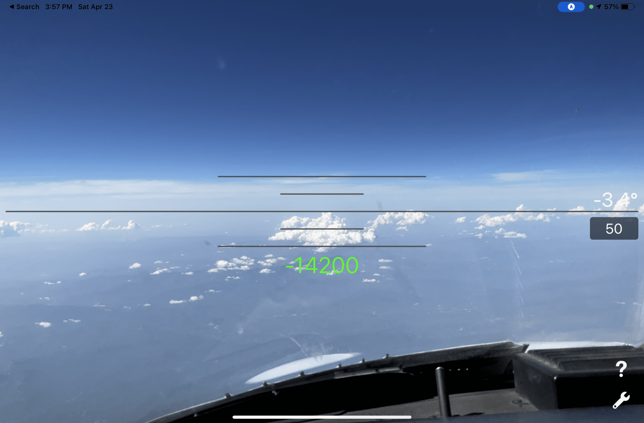
You can also enter the approximate distance from the cloud tops in the dark field just below the degree readout and the app will calculate your height above or below that cloud. In the example below from a high-altitude flight in a Citation, we entered the cloud distance of 50 miles and tilted the iPad screen down to place the reference line at the top of the cumulus clouds. This showed that the tops were approximately 14,200′ below our current altitude:
Whether you’re flying over afternoon cumulus clouds at 8,000 feet, or evaluating thunderstorm tops in the flight levels, this app works pretty well. Of course, you don’t want to rely on this app as your sole source for making an in-flight weather decision, but it sure is a nice tool to have on your iPad or iPhone in the summertime.
Cloud Topper is available for $1.99 in the app store.
- The top 20 apps for pilots – 2026 edition - February 24, 2026
- iOS Update Green Light program: iOS and iPadOS 26.3 - February 12, 2026
- ForeFlight vs. Garmin Pilot: key differences to help you decide - February 10, 2026

