
The 10 Best Weather Apps for Pilots—2026 Edition
|
Getting your Trinity Audio player ready...
|
Thunderstorm season is here, and for pilots that means one thing: weather awareness becomes even more critical. Fortunately, your iPad or iPhone can deliver powerful weather tools right at your fingertips—no need to dig through clunky websites.
But with thousands of weather apps in the App Store, how do you know which ones are actually worth your time?
Most general weather apps are fine for planning a picnic or a weekend hike, but aviation demands more—radar, cloud tops, freezing levels, turbulence, and rapidly changing systems. That’s why we’ve curated a list of the best weather apps for pilots, each offering a unique set of tools to help you plan smarter and fly safer this storm season.
Here are our top 10 weather apps for pilots:
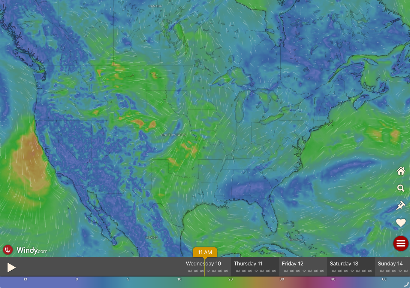
10. Ventusky
Ventusky remains one of the most visually impressive weather apps available.
Ventusky remains one of the most visually impressive weather apps available. It combines traditional forecasts with high-quality model visualizations for wind, temperature, pressure, precipitation, cloud cover, and more.
One of its standout features is the ability to switch between different weather models, giving pilots a more nuanced look at potential forecast scenarios. It’s an excellent tool for developing a better big-picture understanding of the atmosphere before a flight.
9. SkewTLogPro
SkewTLogPro is built for pilots who want to go beyond surface-level weather reports.
It provides Skew-T log(p) diagrams that help interpret atmospheric stability, wind shear, and potential icing or cloud layers. You can pull soundings for specific airports or routes, making it a valuable tool for instrument pilots and weather enthusiasts alike.
8. CloudTopper
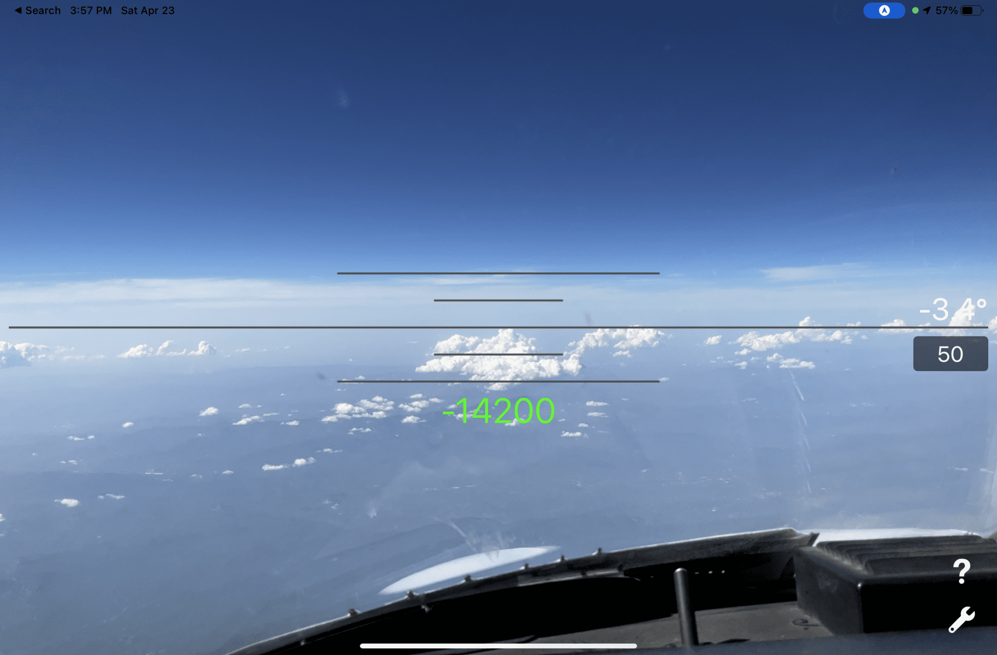
CloudTopper is a unique in-flight tool that uses your device’s camera.
CloudTopper is a unique in-flight tool that uses your device’s camera and sensors to estimate cloud height and determine whether a layer can be topped.
It’s not a primary weather planning tool, but it can be a useful real-time reference when operating near marginal VFR conditions. You can even enter an estimated distance to a cloud layer and receive an estimate of how much altitude would be required to climb above it.
7. METARs Aviation Weather
This app focuses on speed and simplicity for METAR and TAF interpretation.
Favorite airports can be tracked with color-coded flight categories, and plain-language decoding helps cut through the raw text. Custom alerts are a standout feature, allowing pilots to be notified automatically when conditions change at selected airports.
6. StationWeather
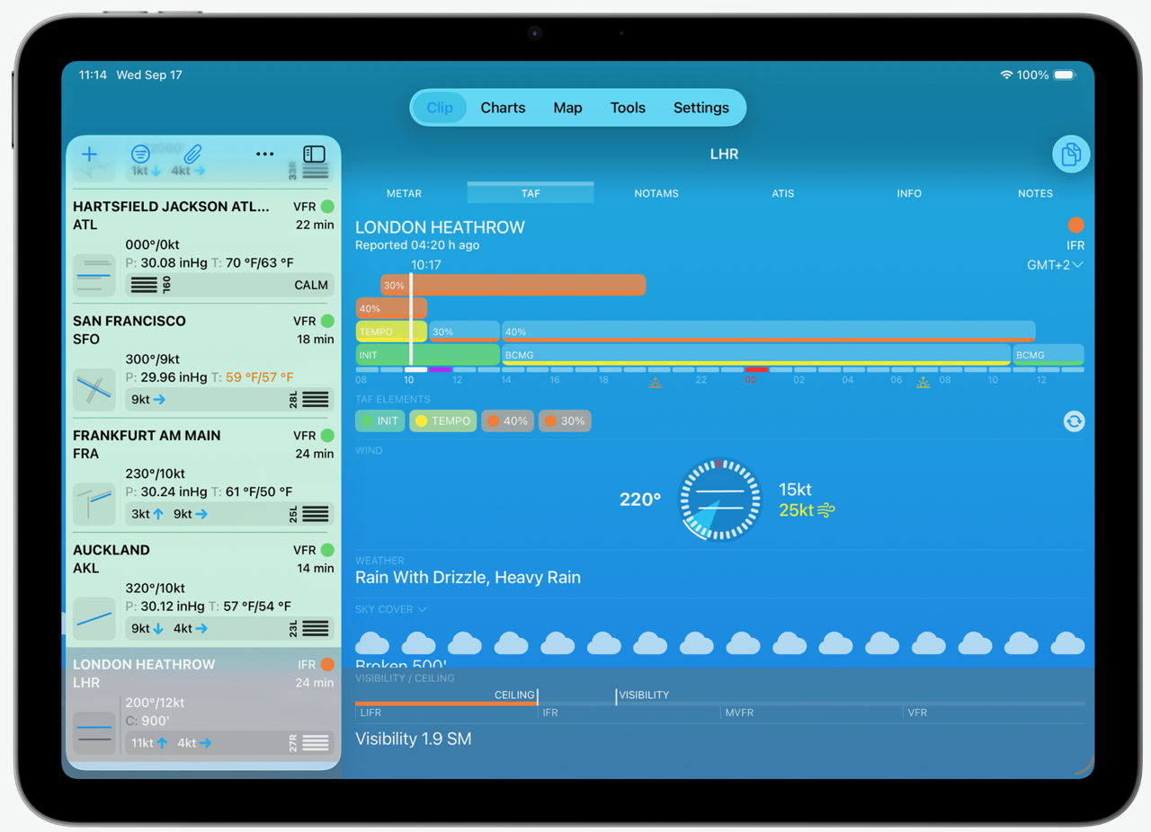
StationWeather is hard to beat for quickly checking multiple METARs and TAFs.
StationWeather is hard to beat for quickly checking multiple METARs and TAFs in a clean, visual format. Favorite airports can be grouped and compared side-by-side, making it especially useful when evaluating alternates or tracking weather trends across a region.
It also does a nice job visualizing forecast changes, helping you quickly see when conditions are expected to improve or deteriorate. With a Pro subscription, you can even display multiple airport METARs on iPad widgets for quick reference.
5. WeatherSpork
WeatherSpork focuses on one of the most important pilot questions: when is the best time to fly?
Its route-based visualization tools make it easy to see VFR, MVFR, IFR, and LIFR conditions along an entire flight path. The app also includes a wealth of forecast graphics and weather products that help pilots move beyond raw observations and into better decision-making.
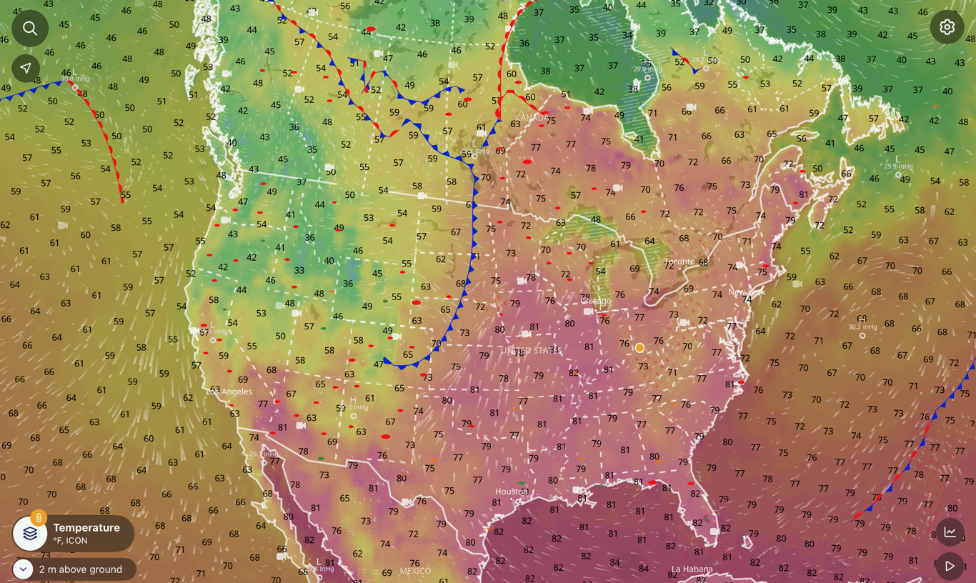
4. Windy
Windy remains one of the best weather visualization tools.
Windy remains one of the best weather visualization tools available for pilots.
It displays wind, pressure, temperature, precipitation, cloud cover, and cloud tops using interactive forecast models. The ability to switch between multiple weather models provides additional insight into forecast uncertainty and developing systems.
It’s an outstanding tool for understanding large-scale weather patterns before a flight.
3. MyRadar
There are hundreds of radar apps in the App Store, but MyRadar continues to stand out for its combination of speed, simplicity, and useful aviation features.
The app offers high-quality radar imagery with smooth animation and intuitive controls. It also includes aviation overlays such as AIRMETs and TFRs, making it a valuable addition to any pilot’s weather toolkit.
2. RadarScope

RadarScope has all kinds of options for viewing different weather products.
If MyRadar is the quick-look radar app, RadarScope is the weather geek’s radar app.
It provides access to more than 150 radar sites and supports advanced products such as base and composite reflectivity, velocity data, and other storm analysis tools. While it requires a bit more knowledge to use effectively, it offers unmatched insight into storm structure and severe weather development.
1. EFB Weather Ecosystem (ForeFlight, Garmin Pilot, and others)
The most important weather app on your iPad may not be a weather app at all—it’s your electronic flight bag.
Whether you use ForeFlight, Garmin Pilot, FltPlan Go, WingX, Stratus Insight, or FlyQ, today’s EFBs combine weather briefing tools, radar, METARs and TAFs, prog charts, icing and turbulence forecasts, and route-based weather overlays into a single platform.
Their biggest advantage is integration. Instead of checking weather separately, you can view it directly in the context of your flight plan, evaluate alternates, compare routing options, and make better decisions. Add in-flight weather from ADS-B or SiriusXM, and these apps become the foundation of modern weather planning and situational awareness.
Get the apps here: ForeFlight, Garmin Pilot, FltPlan Go, WingX, Stratus Insight, and FlyQ.
Editor’s Note: No single weather app can do everything. The best approach is to combine a comprehensive EFB with a few specialized tools that match your flying style. A radar-focused pilot may rely heavily on RadarScope, while an IFR pilot planning long cross-country flights may find WeatherSpork and SkewTLogPro indispensable.
- ADS-B Quiz for Pilots: Test Your Datalink Weather Knowledge - June 16, 2026
- The 10 Best Weather Apps for Pilots—2026 Edition - June 10, 2026
- What to Do When Your iPad Gets Too Hot (or Too Cold) in the Cockpit - June 5, 2026


To the above list, I would add a couple of relatively new aviation apps which appear to be gaining significant market share:
PlaneWx.ai which uses AI, multiple models and data sources to evaluate weather against personal minimums and produce a summarized evaluation for the proposed route and altitude of flight.
EZWxBrief.com which provides a unique time-slider, updating map-depicted METARs/TAFs and future radar based on time of departure and color-coded time-specific gates using personal minimums. It also has a clear profile view, showing clouds, icing and turbulence based on ETA at each point along the planned route of flight.
Here’s another thumbs up for EzWXBrief. Much more than a weather briefing app, it functions like a pro level weather dispatch system. I flew back from SC to the west coast of Florida while the remnants of Andrew were still hanging around. Ordinarily, I try to leave as early as possible to avoid the air mass buildups (as much as possible) that are common this time of year. That morning, the static radar showed a line running coast to coast cutting through Orlando. In times past, this might have meant “stay at home” but EzWxBrief showed that a departure at 10:30 to 11:00 would result with a hole opening up i a specific location as I arrived at the line. Having had experience with EzWxBrief and been impressed by its predictive abilities, I decided to go (with a few strategic options in my back pocket). Lo and behold, just as I was arriving to the line ADSB, XM Weather and onboard radar all confirmed that soft spot opening up. A minute or so later, ATC says, “we have a reroute for you” and they sent me to a fix that cut right through the opening. Light turbulence for about 45 seconds and then clear skies. I still do the full normal weather briefing before anything but local VFR flights but I trust EzWxBrief to give me the real-world story. App was created by Scott Dennestat (sp?) who writes for many aviation publications on weather.