
See before you fly: ForeFlight adds new FAA Weather Cameras
|
Getting your Trinity Audio player ready...
|
 Most pilots today complete their preflight weather briefing in an aviation app like ForeFlight on an iPhone or iPad. Thanks to relaxed guidance from the FAA in recent years on what a preflight weather briefing should look like. Pilots can skip the call to Flight Service and complete this self-briefing in the app using the interactive map weather layers and textual forecasts.
These traditional weather resources only tell part of the story, though. Sometimes, you need to see the weather around an airport to make a final decision. That’s where the FAA’s weather cameras come in. They provide a near-real-time visual picture from hundreds of locations nationwide to show what the conditions look like.
The imagery from these cameras has been accessible from the FAA WeatherCams website for several years, and finally made its way into ForeFlight in the latest app update. In this article, we’ll show how this feature works and cover several other updates included in the app update.
Here’s a quick summary of what’s new, sorted by subscription plan:
Basic – Airport tab in ForeFlight Web, NOTAMs in FIRC/UIR details, Expanded airport contacts, Dark Mode app icon
Pro Plus – FAA weather camera map layer, Reported Turbulence max age setting
Performance Plus – n/a
Weather Cameras in ForeFlight
The FAA weather camera program dates back to the late 1990s, when it was first launched in Alaska to provide pilots better access to visual conditions in remote locations across the state. Today, the program offers over 600 camera sites across the U.S. and continues to grow. As you’ll see from this FAA map, most of the cameras are concentrated in the western half of the U.S., Alaska and Canada:

ForeFlight currently provides access to over 200 weather cameras across 24 states, from the Airports and Maps screens. The best way to get started is by going to the map and selecting the Cameras layer from the list. This will display small camera icons on the map, representing locations where weather cameras are available. The majority of these sites are at airports, but you’ll often see locations near small towns or mountain passes to provide en route imagery as well:

Tap on a camera site to view the most recent capture from that location. You can choose views in up to four fixed headings, each displaying the picture’s age. A new image is captured every 10 minutes from each direction offered:

Next, tap on one of the images to load a pop-up window with a larger view. This view allows the ability to see what a “Clear Day” view looks like using the control at the top right, providing helpful context when viewing an unfamiliar area. Often, this Clear Day image includes callouts and distances to visual landmarks, to help you gauge the current visibility:
 .
. 
If an airport has a weather camera available, you can also access it from the Airports screen under the Info tab:

FAA weather cameras should only be used for supplementary purposes and to improve situational awareness. Not to comply with regulatory requirements, such as official alternate planning for an IFR flight. With that disclaimer out of the way, they’re a tremendous resource for pilots and have already proven their value in Alaska.
According to an FAA Safety Briefing article, the impact of the weather camera program has been outstanding:
Weather-related aircraft accidents dropped 85% in Alaska between 2007 and 2014 as 140 new FAA weather camera sites were added throughout the state, according to a MITRE study. The study also reported that the number of disrupted hours — when a pilot flies out and then turns around because of weather — dropped from 13,588 hours in 2008 to 5,129 hours in 2014, a 62% reduction.
Weather cameras are not just for preflight. As in-flight internet becomes more accessible through Starlink and other satellite systems, they’re a great resource to view en route as you brief the arrival and approach phase of a flight.
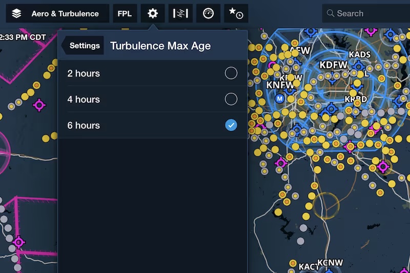
Reported Turbulence Age Filter
 ForeFlight introduced an innovative new feature last year that allows pilots to view the actual turbulence experienced by other airplanes, measured by those flying with a Sentry portable ADS-B receiver. This visual map layer displays color-coded dots indicating location and intensity of turbulence, a valuable preflight planning resource.
In the latest update, ForeFlight added a new setting that allows you to limit the maximum age of turbulence reports to 2, 4, or 6 hours. This lets you declutter the map and view only the most recent reports when needed.
ARTCC NOTAMs on the Map


Expanded Airport Contacts

- iOS Update Green Light program: iOS and iPadOS 26.5 - May 14, 2026
- How to Customize the Control Center on Your iPad or iPhone - May 13, 2026
- Flying with Starlink: Tips, Setup, and Real-World Performance - May 1, 2026


The new cameras option appears on my iphone but not on my ipad. Both are updated to the latest software and ipad has been restarted. Any ideas?